Iran's Borders: Unveiling A Geopolitical Crossroads
Iran's borders are far more than mere lines on a map; they are dynamic interfaces that define the nation's geopolitical standing, cultural exchanges, and economic pathways. This ancient land, nestled in Southwest Asia, boasts a rich tapestry of history and geography, with its boundaries playing a pivotal role in shaping its identity and interactions with the world.
From rugged mountain ranges to vast desert basins and strategic coastlines, understanding the intricate network of Iran's land and maritime borders offers profound insights into this significant Middle Eastern power. This comprehensive guide delves into the specifics of Iran's extensive frontiers, exploring their lengths, unique features, and the profound impact they have on regional dynamics and global affairs.
Table of Contents
- The Strategic Canvas of Iran's Geography
- A Nation Bounded: Iran's Land Neighbors
- Iran's Maritime Horizons: Caspian Sea, Persian Gulf, and Gulf of Oman
- Beyond Lines on a Map: Cultural and Economic Exchanges
- Geopolitical Significance and Border Dynamics
- Navigating Iran's Borders: A Traveler's Perspective
- The Future of Iran's Borders
The Strategic Canvas of Iran's Geography
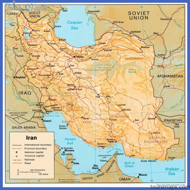
Iran, officially known as the Islamic Republic of Iran, occupies a vast expanse of 1,648,195 square kilometers in southwestern Asia, making it one of the largest countries in the Middle East. This immense territory is characterized by a predominantly rugged landscape of plateaus and mountains, with most of the land situated above 1,500 feet (460 meters). These geographical features are not merely scenic backdrops; they significantly influence the nature and accessibility of Iran's borders.
The country's interior basin is notably surrounded by formidable mountain ranges. To the north, the Elburz Mountains stand as a majestic barrier, while along Iran's western borders, the extensive Zagros Mountains stretch across a significant portion of the country. These natural fortifications have historically played a crucial role in shaping trade routes, military strategies, and the demographic distribution across the region. A political map of Iran vividly illustrates these international borders, alongside major cities, deserts, and coastlines, providing a comprehensive understanding of Iran's complex geography.
Understanding this geographical context is fundamental to appreciating the intricate dynamics of Iran's borders. The challenging terrain often dictates the location of crossing points and the flow of people and goods, making the management of these frontiers a complex endeavor. The interplay of mountains, deserts, and fertile plains creates a diverse environment that directly impacts the characteristics of each of Iran's borders.
A Nation Bounded: Iran's Land Neighbors
Iran shares land borders with seven sovereign countries, each presenting unique historical, cultural, and geopolitical considerations. These extensive land frontiers are vital arteries for trade, cultural exchange, and regional diplomacy. The longest of these land borders is with Iraq, underscoring its significant role in Iran's foreign relations and regional stability. The full list of countries sharing land borders with Iran includes:
- Iraq
- Turkmenistan
- Afghanistan
- Pakistan
- Azerbaijan
- Turkey (Turkiye)
- Armenia
Each of these borders tells a different story, reflecting centuries of interaction, cooperation, and, at times, conflict. The sheer length and diversity of these land connections make Iran a central figure in the geopolitics of the Middle East and Central Asia.
The Western Frontiers: Iraq and Turkey
To its west, Iran shares two of its most historically significant and geopolitically active land borders: with Iraq and Turkey.
The border with **Iraq** stands as Iran's longest land frontier. This extensive boundary has been a focal point of numerous historical events, including prolonged conflicts, and continues to hold immense geopolitical importance. It is a region where cultural and religious ties run deep, influencing cross-border movements and interactions. The management of this border is crucial for regional security and economic stability, facilitating both official crossings and informal trade routes.
Further north, Iran shares its western border with **Turkey (Turkiye)**. This border serves as a critical gateway for both passenger travel and commercial trade between the two countries and onward to Europe. Citizens seeking to depart Iran by land often utilize the Turkish borders, which are generally well-established and facilitate significant cross-border traffic. The stability and functionality of this border are vital for regional connectivity and economic integration.
The Northern Arc: Azerbaijan, Armenia, and Turkmenistan
Iran's northern boundaries are defined by a trio of countries – Azerbaijan, Armenia, and Turkmenistan – along with the vast expanse of the Caspian Sea. These borders reflect Iran's historical ties to the Caucasus and Central Asia.
The border with **Azerbaijan** spans approximately 765 kilometers. This border region holds significant geopolitical importance, particularly due to its proximity to the Caspian Sea and its role in regional energy transit. Beyond geopolitics, this border has played a crucial role in fostering cultural exchanges, especially in terms of art, music, and cuisine, reflecting a shared heritage that transcends political lines.
To the northwest, Iran borders **Armenia**. This land border, particularly the crossing point at Agarak, is a vital link for trade and travel. As of recent reports, the land border with Armenia (Agarak) has been confirmed as open for citizens seeking to depart Iran by land, highlighting its reliability as a transit route in the region.
Completing the northern arc, Iran shares a border with **Turkmenistan**. This frontier connects Iran to Central Asia, facilitating trade and cultural interactions with a region that shares historical and linguistic ties. The characteristics of this border often involve arid landscapes and a focus on energy and agricultural exchanges.
The Eastern Gates: Afghanistan and Pakistan
To its east, Iran shares extensive and often challenging land borders with Afghanistan and Pakistan, regions characterized by rugged terrain and complex geopolitical dynamics.
**Afghanistan** shares a land border with Iran, which lies to the east of Iran, stretching for around 921 kilometers. This border is particularly significant due to the historical movement of people, including refugees, and the challenges associated with border security, given the volatile situation in Afghanistan. Despite the complexities, the border remains a crucial conduit for humanitarian aid and limited trade, reflecting the deep-seated connections between the two nations.
The **Iran–Pakistan border**, also known as the Persian: مرز ایران و پاکستان; Urdu: ایران پاکستان سرحد, spans 909 kilometers (565 miles). It demarcates the Iranian province of Sistan and Baluchestan from the Pakistani province of Balochistan. This border region is known for its challenging desert and mountainous terrain, which historically made border control difficult. In recent years, Iran has undertaken significant efforts to enhance security along this frontier. Notably, "in the eastern borders, around 150 kilometers of these walls have already been built," indicating a concerted effort to manage and secure these remote areas.
The geopolitical landscape of this border is highly dynamic. For instance, the ongoing conflict between Iran and other regional actors has started affecting Balochistan, with the provincial government issuing orders to close all borders and crossing points with Iran in Turbat. Such closures underscore the sensitive nature of these **Iran borders** and their immediate impact on local populations and regional stability. Furthermore, neighboring countries are constantly considering how they might respond if the outflow of people spills across Iran’s borders, drawing lessons from past crises like Syria’s civil war, which saw millions of refugees.
Iran's Maritime Horizons: Caspian Sea, Persian Gulf, and Gulf of Oman
Beyond its extensive land frontiers, Iran's geography is equally defined by its significant maritime boundaries, which are crucial for its economy, security, and international relations.
To its north, Iran is bounded by the **Caspian Sea**, the largest lake on Earth, with an estimated surface area of 371,000 square kilometers. While technically a lake, its sheer size and strategic importance, particularly concerning energy resources and shipping routes, give it the characteristics of a sea. Iran's access to the Caspian Sea is vital for trade with Central Asian nations and Russia, and it plays a significant role in regional environmental and geopolitical discussions.
To its south, Iran borders the vital waterways of the **Persian Gulf and the Gulf of Oman**. These southern limits are arguably the most strategically important of all Iran's borders. The Persian Gulf is a critical artery for global oil shipments, making Iran a key player in international energy markets. The Gulf of Oman provides direct access to the open waters of the Arabian Sea and beyond, bypassing the Strait of Hormuz, offering an alternative maritime route. These maritime boundaries are not just lines on a map; they are dynamic zones of international trade, naval activity, and environmental concern, constantly shaping Iran's interactions with the global community.
Beyond Lines on a Map: Cultural and Economic Exchanges
The significance of Iran's borders extends far beyond their geopolitical and strategic dimensions. These boundaries are, in essence, vibrant gateways that facilitate lively economic interactions and profound cultural exchanges. The flow of goods, ideas, and people across these frontiers has historically enriched Iran and its neighbors, fostering a tapestry of shared traditions and mutual understanding.
In terms of culture, the border regions have been melting pots where different influences converge, especially evident in art, music, and cuisine. For instance, along the Azerbaijani border, shared musical traditions and culinary practices are commonplace, reflecting centuries of intermingling populations. Similarly, the eastern **Iran borders** with Afghanistan and Pakistan have seen a rich exchange of artisanal skills, literary traditions, and even religious practices, creating unique regional identities that straddle national lines.
Economically, these borders are crucial for trade, both formal and informal. They serve as conduits for the import and export of goods, facilitating regional commerce and supporting local economies in border towns. The concept of "economic chats" highlights the continuous dialogue and transactions that occur daily, driven by the needs and opportunities presented by cross-border interactions. These exchanges underscore that Iran's boundaries aren't just lines of demarcation but living, breathing interfaces that connect communities and economies.
Geopolitical Significance and Border Dynamics
Iran, geographically located in Asia and boasting access to both the Persian Gulf and the Caspian Sea, is undeniably a significant geopolitical player in the region. The intricate network of its borders is central to this status, as each frontier presents unique challenges and opportunities that influence regional stability and international relations.
The geopolitical importance of Iran's border regions cannot be overstated. They are often at the forefront of regional tensions and global concerns. Recent events, such as Pakistan closing its border with Iran in response to regional conflicts, illustrate the immediate and profound impact of geopolitical shifts on these frontiers. Such closures affect not only trade and travel but also highlight the vulnerability of border communities to broader political developments.
Furthermore, the potential for humanitarian crises stemming from regional instability is a constant concern. Neighboring countries are keenly aware of the possibility of large-scale refugee outflows spilling across Iran’s borders, reminiscent of the crisis caused by Syria’s civil war, which saw 6 million refugees seeking safety. This foresight underscores the critical role of Iran's border management in maintaining regional humanitarian stability.
For citizens, these geopolitical dynamics directly impact travel. Those seeking to depart Iran by air are always advised to confirm travel plans with their airlines, as situations can change rapidly. Similarly, for land travel, specific border crossings like the Armenian border (Agarak) being open as of a certain date (e.g., Monday, June 16, as noted in the data) provide crucial information, while the status of Turkish borders for departure also remains a point of regular update for travelers.
The constant monitoring and adaptation of border policies in response to evolving geopolitical realities are a testament to the dynamic nature of Iran's international boundaries.
Navigating Iran's Borders: A Traveler's Perspective
For travelers and those interested in understanding the practicalities of Iran's geography, a guide to "Iran country size and borders length" offers a better perspective. This information is invaluable for planning journeys, understanding transit routes, and appreciating the sheer scale of the country and its connections to its neighbors.
Iran's official currency is the Rial (IRR), and while Persian is the primary language, Kurdish is also widely spoken, especially in western border regions. These details, combined with knowledge of border crossings, are essential for anyone planning to interact with or travel through Iran's diverse borderlands.
Whether it's the bustling land crossings with Turkey, the culturally rich frontiers with Azerbaijan, or the more remote and challenging eastern **Iran borders** with Afghanistan and Pakistan, each offers a unique experience. The ability to cross these borders, whether for tourism, business, or family visits, underscores their role as essential arteries connecting Iran to the wider world. The ease or difficulty of these crossings often reflects the broader political climate, making them barometers of regional relations.
The Future of Iran's Borders
The future of Iran's borders will undoubtedly continue to be shaped by a complex interplay of internal developments, regional dynamics, and global geopolitical shifts. As a country situated at a critical crossroads of Asia, the Middle East, and the Caspian region, the management and evolution of its frontiers remain paramount.
Ongoing efforts to enhance border security, such as the construction of walls on the eastern borders, reflect a commitment to national sovereignty and stability. Simultaneously, the enduring cultural and economic ties across these boundaries will likely continue to foster exchanges, even amidst political complexities.
The role of Iran's borders as conduits for trade, migration, and cultural diffusion will persist, adapting to new challenges and opportunities. Understanding these intricate lines on the map is not just about geography; it's about comprehending the past, present, and future trajectory of a nation deeply intertwined with its neighbors and the global community.
Conclusion
In conclusion, Iran's borders are multifaceted entities, extending across vast landmasses and vital maritime zones. From the rugged peaks of the Zagros Mountains bordering Iraq and Turkey, to the strategic waters of the Persian Gulf and the Caspian Sea, each boundary tells a story of history, culture, and geopolitics. With land borders shared with seven distinct countries—Iraq, Turkmenistan, Afghanistan, Pakistan, Azerbaijan, Turkey, and Armenia—and crucial maritime access, Iran stands as a pivotal nation in Southwest Asia.
These **Iran borders** are not static lines but dynamic interfaces that facilitate economic exchanges, cultural diffusion, and, at times, reflect regional tensions. Their length, geographical features, and historical significance underscore Iran's central role as a key geopolitical player. As the region continues to evolve, the intricate dance along Iran's frontiers will undoubtedly remain a focal point of international interest and a testament to the enduring connections between nations.
What are your thoughts on the significance of Iran's extensive borders? Share your insights in the comments below! If the travel bug bites and you’re curious about other countries’ buddies, you can also peek at pieces on Ecuador’s neighbors, Egypt’s friends, and Ethiopia’s bordering pals right here on our site.
- Iran Washington Embassy
- Corinna Dated And Related
- Iran Then Now
- Posiciones De Leagues Cup
- Iran Strike On Israel Imminent

AFG Iran Border Map • mappery

LECTURES & EVENTS – The Iran Society
Iran Map - ToursMaps.com
