Unveiling Iran's Geography: A Land Of Mountains & Ancient Routes
Table of Contents
- Iran's Strategic Location: A Crossroads of Continents
- The Vastness of Iran: Understanding Its Scale
- Iran's Dominant Topography: A Mountainous Heartland
- The Lowlands and Plains: Pockets of Fertility
- Arid Basins and Deserts: Iran's Interior
- The Armenian Highlands Connection: Northwestern Iran
- Climate and Natural Resources: A Brief Overview
- The Geographic Influence on Iran's History and Culture
Iran's Strategic Location: A Crossroads of Continents
The geographical positioning of Iran is undeniably one of its most defining characteristics, granting it a pivotal role throughout history and into the modern era. Situated squarely in Southwestern Asia, Iran occupies a critical nexus, linking the Middle East, Central Asia, and the Indian subcontinent. This unique placement has made it a historical crossroads for trade, culture, and military movements, shaping its identity as a land of empires and enduring influence.Location in Southwest Asia
Iran lies at the easternmost edge of the geographic and cultural region known as the Middle East, specifically in Southwest Asia. This placement means it shares borders and cultural affinities with a diverse array of nations, making it a central player in regional dynamics. Its land boundaries are extensive and varied, reflecting the complex geopolitical landscape of the area. To the north, Iran shares borders with Armenia, Azerbaijan, and Turkmenistan. Moving eastward, its landmass adjoins Afghanistan and Pakistan. To the west, Iran neighbors Iraq and Turkey, two countries with whom it shares significant historical and cultural ties. This intricate web of land borders underscores Iran's role as a bridge between different sub-regions of Asia.Borders and Maritime Access
Beyond its numerous land borders, Iran also boasts extensive maritime boundaries that are crucial to its economic and strategic interests. The Caspian Sea defines its northern boundary, a vast inland sea that connects Iran to Russia and other Central Asian states. To its south, the Persian Gulf and the Gulf of Oman mark its southern limits, providing vital access to international shipping lanes and the global economy. The Strait of Hormuz, a narrow waterway connecting the Persian Gulf to the Gulf of Oman and the Arabian Sea, is particularly significant. Iran's control over a substantial portion of this strait gives it immense strategic leverage, as a significant percentage of the world's oil supply passes through these waters. This dual access—to both the Caspian Sea in the north and the Persian Gulf in the south—amplifies Iran's geopolitical importance, making it a critical player in both regional and global energy markets.Geostrategic Significance
With an area of 1,648,195 square kilometers, Iran's central location in Eurasia gives it special geostrategic significance. This vast landmass, combined with its maritime access, positions Iran as a natural gateway. Historically, it has been a crucial passage from neighboring Iraq, Turkey, and the Arab states to Central Asia. This role as a transit hub has contributed to its long history as an imperial power and a factor in superpower rivalries. The topography of Iran, characterized by rugged, mountainous rims surrounding high interior basins, further emphasizes its natural defensive capabilities while also dictating the flow of trade and communication routes. The interplay of its physical geography and its location has consistently placed Iran at the heart of regional and international affairs, making its geography a cornerstone of its geopolitical standing.The Vastness of Iran: Understanding Its Scale
To truly grasp the geography of Iran, one must first appreciate its sheer size. It is a country of immense proportions, ranking among the largest nations globally. This vastness contributes significantly to its diverse landscapes, varied climates, and the challenges and opportunities inherent in governing such an expansive territory. The scale of Iran is a testament to its capacity to encompass a multitude of geographical features within its borders.Size and Global Comparison
Iran occupies 1,648,195 square kilometers in Southwestern Asia. This makes it the sixteenth largest country in size globally, though some sources may list it as the eighteenth largest depending on the exact calculation methods and inclusion of disputed territories. To put this into perspective, Iran's area roughly equals that of the United Kingdom, France, Spain, and Germany combined. Alternatively, it is slightly less than the state of Alaska in the United States. This substantial landmass means that traveling across Iran involves traversing vast distances and encountering dramatically different environments, from snow-capped peaks to scorching deserts and humid coastal plains. The immense scale of the country is a fundamental aspect of its geography, influencing everything from its climate patterns to its population distribution and infrastructure development. This expansive territory has historically provided both strategic depth and a wide array of natural resources, contributing to Iran's enduring resilience and importance in the region.Iran's Dominant Topography: A Mountainous Heartland
The landscape of Iran is overwhelmingly defined by its rugged mountain ranges, which are the most prominent feature of its topography. These formidable natural barriers separate various basins or plateaus from one another, creating a complex and diverse terrain. Indeed, Iran is one of the world's most mountainous countries, with mountains covering almost exclusively its landmass, dictating settlement patterns, climate zones, and even cultural divisions.The Rugged Landscape
The topography of Iran consists primarily of rugged, mountainous rims surrounding high interior basins. This structure means that while there are vast plains, they are often nestled between towering peaks. The western part of the country is particularly mountainous and populous, reflecting the availability of water resources and more temperate climates in these elevated regions. This ruggedness has historically provided natural defenses, making invasions difficult and contributing to the longevity of Persian civilization. The interplay of high mountains, deep valleys, great flatlands, and vast arid deserts creates a striking visual contrast across the Iranian landscape, offering a wide spectrum of natural environments within a single nation.The Mighty Zagros Mountains
Among Iran's most significant mountain chains are the Zagros Mountains. This extensive range is a series of parallel ridges interspersed with plains that effectively bisect the country from northwest to southeast. The Zagros Mountains run down the western side of Iran, alongside the Persian Gulf, forming a natural boundary and influencing weather patterns significantly. Their rugged terrain has historically limited access to the interior from the west, funneling movement through specific passes. The Zagros system is not just a geographical feature but also a cultural and ecological zone, home to diverse ethnic groups and unique biodiversity. The valleys within the Zagros are often fertile, supporting agriculture and ancient settlements, while the higher elevations are characterized by harsh winters and limited human habitation.The Majestic Alborz Range and Mount Damavand
In the northern part of Iran lies another majestic mountain range, the Alborz Mountains. This range is particularly significant as it contains Iran's highest point, Mount Damavand. Standing at an impressive 5,671 meters (18,606 feet), Mount Damavand is not only the highest peak in Iran but also the highest volcano in Asia. Its snow-capped conical peak is an iconic symbol of Iran, visible from Tehran on clear days. The Alborz Mountains form a formidable barrier between the Caspian Sea coastal plain and the vast central plateau of Iran. This barrier plays a crucial role in Iran's climate, trapping moisture from the Caspian Sea on its northern slopes, leading to lush, humid conditions, while casting a rain shadow over the central plateau, contributing to its arid nature. The Alborz range, like the Zagros, is also a region of significant ecological and recreational importance, offering opportunities for mountaineering, skiing, and diverse wildlife.The Lowlands and Plains: Pockets of Fertility
While Iran is predominantly mountainous, it is not without its significant lowlands and plains. These areas, though limited in expanse, are crucial for agriculture, population centers, and economic activity. They represent vital pockets of fertility and strategic importance, contrasting sharply with the surrounding rugged terrain and vast deserts. Iran has only two primary expanses of lowlands, each with distinct characteristics and historical significance.The Khuzestan Plain
One of Iran's two major lowlands is the Khuzestan Plain, located in the southwest of the country. This plain is part of the broader Mesopotamian plain and is historically and economically vital. Situated near the Persian Gulf, the Khuzestan Plain is characterized by its flat terrain, fertile soil, and the presence of major rivers, most notably the Karun River, Iran's only navigable river. This region has been a cradle of civilization for millennia, supporting ancient empires due to its agricultural productivity. Today, it remains a critical agricultural hub, producing a variety of crops. Furthermore, Khuzestan is immensely significant for its vast oil and gas reserves, making it the heart of Iran's energy industry. Its strategic location near the Persian Gulf and its rich natural resources have made it a focal point for both domestic development and international attention throughout history.The Caspian Sea Coastal Plain
The second major lowland expanse is the Caspian Sea Coastal Plain, situated in the north of Iran. This plain is a narrow strip of land nestled between the Alborz Mountains and the Caspian Sea. In stark contrast to the arid interior and the hot, sometimes humid, Khuzestan Plain, the Caspian coastal plain enjoys a humid, subtropical climate with abundant rainfall. This unique climate, influenced by the moisture trapped by the Alborz Mountains, results in lush forests, rice paddies, and tea plantations. It is one of the most densely populated regions of Iran, known for its vibrant green landscapes and distinct cultural traditions. The Caspian Sea itself is the world's largest inland body of water, offering fishing opportunities and playing a role in regional trade. This northern lowland provides a vital agricultural base and a different ecological zone within Iran's diverse geographical tapestry.Arid Basins and Deserts: Iran's Interior
Beyond its towering mountains and fertile lowlands, a significant portion of Iran's interior is characterized by arid basins and vast deserts. These regions, often referred to as plateaus, are a defining feature of the country's geography, contributing to its overall arid climate and presenting unique environmental challenges. The sparse population and extreme conditions in these areas contrast sharply with the more temperate and densely populated mountainous and coastal regions.Interior Plateaus and Basins
The central part of Iran is dominated by a high interior plateau, which is surrounded by the rugged, mountainous rims mentioned earlier. This plateau is not uniformly flat but consists of several distinct basins. These basins are typically endorheic, meaning they have no outflow to the sea, leading to the accumulation of salt and the formation of salt lakes and vast salt flats. The topography of Iran, with its mountainous rims surrounding these interior basins, effectively creates a rain shadow effect. Moisture-laden air from the seas is largely blocked by the high mountains, resulting in very low precipitation in the central plateau. This geographical configuration contributes significantly to the arid and semi-arid conditions prevalent across much of Iran's interior.The Arid Nature
Iran is fundamentally an arid country. The vast central plateau is home to some of the world's most formidable deserts, including the Dasht-e Kavir (Great Salt Desert) and the Dasht-e Lut (Empty Desert). These deserts are characterized by extreme temperatures, vast expanses of sand dunes, salt marshes, and barren lands. The Dasht-e Lut, for instance, is one of the hottest and driest places on Earth, with some of its areas holding the record for the highest surface temperature ever recorded. Life in these regions is challenging, with settlements typically confined to oases or areas where underground water sources (qanats) can be tapped. Despite their harshness, these deserts are not devoid of life; unique flora and fauna have adapted to these extreme conditions. The presence of these vast arid regions significantly impacts Iran's water resources, agricultural potential, and population distribution, making water management a critical aspect of national policy.The Armenian Highlands Connection: Northwestern Iran
While the Zagros and Alborz mountains dominate much of Iran's landscape, the northwestern part of the country connects to a distinct geographical feature: the Armenian Highlands. This topographical link underscores Iran's position as a bridge between various geographical and cultural regions, extending its influence and shared natural features beyond its immediate borders. Parts of northwestern Iran are indeed part of the Armenian Highlands. This region adjoins Iran topographically with other parts of neighboring Turkey, Armenia, Azerbaijan, and Georgia. This shared highland system means that the landscapes, geological formations, and even some climatic patterns in this corner of Iran bear resemblances to those found in the Caucasus region. The Armenian Highlands are characterized by high plateaus, volcanic mountains, and deep river valleys, providing a distinct geographical character to northwestern Iran compared to the central plateau or the southern lowlands. This area has historically been a corridor for movement and interaction between Iran and the Caucasus, influencing cultural exchanges and trade routes. The mountainous terrain here, while part of a broader regional system, still contributes to Iran's overall rugged and elevated profile, further diversifying its already rich geographical tapestry.Climate and Natural Resources: A Brief Overview
The diverse geography of Iran, encompassing high mountains, arid deserts, and fertile plains, naturally leads to a wide range of climates and the presence of significant natural resources. While the "Data Kalimat" provided doesn't delve into extensive detail on these aspects, it highlights their importance as topics to understand when studying Iran's geography. Iran's climate is predominantly arid and semi-arid, particularly across its vast central plateau and southern regions, influenced by the rain shadow effect of the Zagros and Alborz mountains. Summers are generally hot and dry, while winters can be cold in mountainous areas and mild in the south. The Caspian Sea coastal plain, however, stands out with its humid, subtropical climate and abundant rainfall, a stark contrast to the rest of the country. This climatic diversity supports a variety of ecosystems, from the lush forests of the north to the sparse vegetation of the deserts. In terms of natural resources, Iran is exceptionally rich. Its strategic location on the Persian Gulf and Strait of Hormuz is largely due to its immense reserves of oil and natural gas, particularly in the Khuzestan Plain, making it a major global energy producer. Beyond hydrocarbons, Iran also possesses significant deposits of minerals such as copper, iron ore, lead, zinc, and coal, which contribute to its economic potential. The availability of water, however, remains a critical challenge, especially in the arid interior, necessitating extensive water management strategies.The Geographic Influence on Iran's History and Culture
The geography of Iran has not merely been a backdrop for its history; it has been an active participant, shaping the rise and fall of empires, the flow of cultures, and the very identity of its people. For thousands of years, Iran's unique physical attributes have dictated its strategic importance, its cultural resilience, and its role as a bridge between diverse civilizations.Ancient Civilizations and Empires
The Iran of today stands upon an ancient base of civilization and culture. Long a crossroads for conquerors, its geographical position as a gateway between East and West, and North and South, made it a coveted territory. The fertile plains, particularly the Khuzestan Plain, provided the agricultural base necessary for the emergence of early complex societies. The protective mountain ranges offered natural defenses, allowing the Persian Empire to flourish for centuries. Known in the West as Persia since the beginnings of historical records associated with Cyrus the Great in the 6th century B.C.E., Iran was the heart of an ancient empire that stretched across vast territories. Alexander the Great brought Hellenistic culture to Persia in the 4th century B.C.E., and this event opened the gate to a long procession of foreign dynasties, each leaving their mark on the ethnically diverse country. The rugged terrain and the vastness of the land also meant that while conquerors might sweep through, pockets of local culture and resistance often endured, contributing to the resilience of Iranian identity.A Gateway to the East
Iran's geographical position has consistently made it a crucial gateway. It has long been a passage from neighboring Iraq, Turkey, and the Arab states to Central Asia, facilitating trade routes like the Silk Road. This role as a transit hub meant that goods, ideas, and people constantly flowed through Iran, enriching its culture and contributing to its ethnic diversity. Modern Iranian culture owes itself in part to a renaissance in the 8th century, which absorbed and synthesized influences from various directions, a process facilitated by its open geographical corridors. The strategic location, coupled with its natural resources, has ensured that Iran has long played an important role in the region as an imperial power and as a factor in superpower rivalries. The challenges of its arid climate and mountainous terrain also fostered ingenuity in water management and agricultural techniques, further shaping its societal development. The geography of Iran, with its mountains, rivers, and plains, has truly been Iran's soul for 3000 years, defining its historical trajectory and cultural depth.Conclusion
The geography of Iran is a story of contrasts and strategic importance, a captivating blend of towering mountains, vast arid deserts, and vital coastal plains. From the rugged peaks of the Zagros and Alborz ranges, including the majestic Mount Damavand, to the fertile Khuzestan and Caspian Sea coastal plains, Iran's diverse landscape has profoundly shaped its identity. Its immense size, covering 1,648,195 square kilometers, positions it as a significant landmass in Southwestern Asia, acting as a crucial crossroads between continents and civilizations. This intricate geographical tapestry has not only influenced Iran's climate and natural resources but has also been a defining factor in its rich history, fostering ancient empires and serving as a vital gateway for trade and cultural exchange. Understanding the unique geography of Iran is essential for anyone seeking to comprehend its historical resilience, its current geopolitical standing, and its enduring cultural heritage. We hope this comprehensive exploration has provided valuable insights into the remarkable geography of Iran. What aspects of Iran's landscape do you find most intriguing? Share your thoughts in the comments below, and feel free to share this article with others who might be interested in learning more about this fascinating country.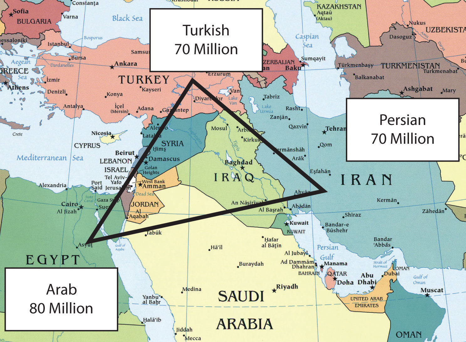
A Crossroads Of History And Culture: Exploring The Map Of Turkey And

Iran Traditional Dress Collaborative Geography and Culture Poster Activity
Why does Iran have a nuclear program? | Britannica
